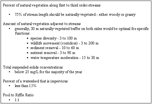
| Table 5. An example of riparian habitat guidelines being used to protect and enhance ecological health of subwatersheds. |
 |
The morning panel discussion was held to identify and help focus on habitat needs and priorities for the Detroit River and its watershed. The panel discussion was initiated with an introductory talk for which an abstract is presented below.
Dan Lebedyk, Essex Region Conservation Authority (ERCA)
The Habitat Technical Work Group of the Detroit River RAP has developed recommendations to address the loss of fish and wildlife habitat through the following two objectives:
The following priority recommendations from the RAP would indirectly address all of the impaired beneficial uses to the Detroit River Area of Concern, including Loss of fish and wildlife habitat and Degradation of fish and wildlife populations:
Currently, there is no existing habitat management plan/strategy for the greater Detroit River Area of Concern. A completed strategy would provide a "road map" of the extent of existing habitat and identify what is required for habitat protection, restoration and enhancement. The Detroit River RAP has identified this as essential for: governmental organizations in their regulatory and planning activities; developers with real estate interests; and recreational and environmental groups. Environment Canada, in partnership with other governmental agencies, has developed a document entitled "A Draft Framework for Guiding Habitat Rehabilitation in Great Lakes Areas of Concern" which provides a methodology to establish habitat restoration guidelines and priorities for degraded ecosystems utilizing Geographical Information Systems (GIS) technology. This document will provide the technical basis upon which a Conservation Biodiversity Strategy will be developed.
ERCA is currently producing a spatial database of all natural areas within the five Ontario sub-watersheds of the greater Detroit River Area of Concern (i.e., Detroit River, Little River, Turkey Creek, Canard River, and Big Creek) and is undertaking an analysis of the natural vegetation within terrestrial, wetland, and aquatic habitats to help set priorities for habitat rehabilitation and enhancement. Strategic planning for the rehabilitation and restoration of ecosystem features focusses on identifying high priority opportunities to help restore or improve environmental features and ecological functions that have been lost or degraded. The overall objective is to increase the size, extent, and quality of key natural heritage features, natural corridors, and greenway linkages, thereby improving the ecosystem diversity and ecological functions of the watersheds. This is the first step to constructing a healthy, self-sustaining, natural heritage system. This holistic approach that works towards restoring, to the extent possible, the functions and diverse species composition that comprise a whole ecosystem is more likely to ensure that maximum biodiversity is conserved over the long term.
Considerable information was compiled to construct the GIS database. The Canadian 1:50,000 and Ontario 1:10,000 topographic base maps (i.e., drainage, roads, vegetation, etc.), and Ontario Ministry of Agriculture and Food 1:25,000 drainage maps were obtained prior to the start of this project. Information on Environmentally Significant Areas (ESAs) and sub-watersheds were obtained from ERCA. Information on Areas of Natural and Scientific Interest (ANSI) and Provincially Significant Wetland boundaries were obtained from the OMNR. Soils and physiography data (1:63,360 maps) were obtained form the Ontario Ministry Agriculture, Food, and Rural Affairs. Wetland boundary mapping (1:2,000) data were acquired from the Town of La Salle. Forest cover and other landcover information was obtained from Landsat Satellite images, through contacts at Parks Canada. All digital information was imported into an ARC/INFO-GIS software package to conduct spatial analysis. This GIS database will help in generating maps and documentation to describe the current state of natural vegetation and adjacent land use, and ultimately areas for possible rehabilitation. A scale of 1:50,000 will be used only for a broad view of existing habitat in an area as a first attempt at identifying possible habitat rehabilitation areas. Detailed maps (1:10,000) will incorporate information gathered through research with Parks Canada, satellite imagery, 1:8,000 aerial photography, and landowner contact. This will provide the basis for the development of a habitat strategy for all five sub-watersheds, and specifically for priority restoration areas.
ERCA is coordinating the development of a Conservation Biodiversity Strategy in association with a technical steering committee made up of various representatives from the professional and local community. Spatial analysis, using overlay and buffering techniques, was the primary technique used throughout this project to determine how the various study areas met the restoration guidelines developed by the steering committee. ERCA will also use its GIS and existing digital data to model soil loss and loading into watersheds at 1:50,000 scale. This modelling will define initial priority areas and direct the landowner contact program to areas which are of high concern, rather than general contact throughout watersheds. This will focus the implementation strategies on areas which are not only "best bets" from a landowner perspective, but more importantly, areas which are high priority for habitat restoration from a biological perspective.
This effort is developing appropriate interim environmental guidelines to protect/maintain, restore/enhance and monitor all the various habitat types of the sub-watersheds. The guidelines will be based on input from the technical subcommittee, the results of on-going investigations and realistic expectations for the long-term health of the sub-watersheds. The environmental guidelines will be used to develop and provide support and rationale for restoration/management strategies. Accordingly, the guidelines reflect an overall desire to ensure that the ecosystem integrity of the sub-watersheds is maintained and, where possible, enhanced after potential and proposed land use changes are made. In addition, the guidelines are aimed at restoring, within practical limits, healthy, self-sustaining, resource-rich conditions, those aspects of the ecosystem that have been lost or degraded over time (Tables 5-7).
| Table 5. An example of riparian habitat guidelines being used to protect and enhance ecological health of subwatersheds. |
|
| Table 6. An example of guidelines being used to promote healthy, self-sustaining woodland ecosystems. |
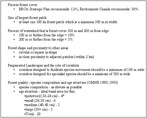 |
* This is a relatively new protocol, established by OMNR foresters for managing a forest stand for structural quality. The above numbers represent different age classes of trees and the relative proportion of these in a forest stand for optimal structural diversity. The units of the numbers are in meters squared per hectare and represent the total basal area of the different age classes of trees in the stand using a special prism for measurement. It is felt that if a total basal area is around 20 and the proportions listed above are achieved, the forest is healthy, productive, and diverse from a structural standpoint.
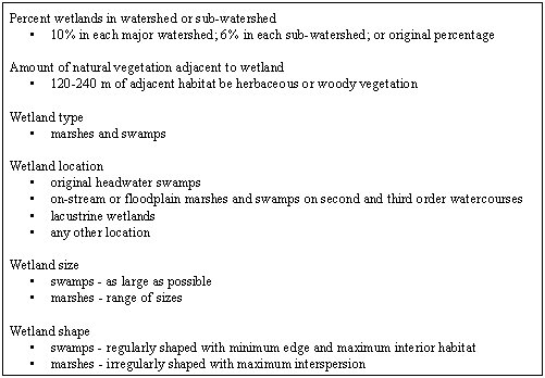
| Table 7. An example of guidelines for the protection and restoration of wetlands. |
 |
Due to the history of land use in the Essex region, especially agricultural land clearing, there are few natural areas remaining. Consequently, further losses should be prevented to the greatest extent possible. Coordinated steps should be taken to rebuild a pattern in the landscape of nodes and corridors of natural features that will improve and diversify the ecology of the greater Area of Concern. A set of principles and goals have been developed to: protect and enhance the sub-watershed natural features and ecological functions; restore those features/functions that have been degraded; and guide future development in a manner that will ensure the long-term health of the environment. These principles and goals will guide the development of a habitat strategy. Goal achievement will be accomplished through full implementation of the strategy. Presented below is an overview of these principles and goals:
Goals:
Goals:
Goals:
Following the introductory talk, panelists entered into an interactive discussion with the audience. Panelists included:
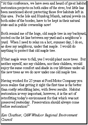
Dan Ballnik (Ford Motor Company, Dearborn, MI);
Lynda Corkum (University of Windsor, Windsor, ON (Moderator));
Brooks Dean (Dean Construction Company, La Salle, ON);
Jon Lovett Doust (University of Windsor, Windsor, ON);
Brian McHattie (Consultant to Environment Canada, Burlington, ON)
Scott Staelgraeve (Ducks Unlimited, Ann Arbor, MI); and
Gary Towns (Michigan Department of Natural Resources, Livonia, MI).
Major points emphasized by panelists included:
Conference participants learned about a number of successful habitat rehabilitation and conservation projects in the Detroit River watershed (e.g., Ruwe Marsh, Stony Island, Belle Isle). Indeed, there have been many such projects that need to be celebrated. However, it was also noted that, despite such projects, habitats continue to be lost and degraded. For example, ERCA has reported a 96% loss of wetlands on the Canadian side of the Detroit River and a 97% loss of tree cover. It was also noted that 97% of the coastal wetlands on the U.S. side of the river have been lost to development (only 3% remains in Humbug Marsh).
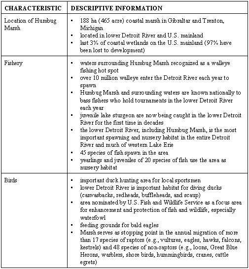
| Table 8. The ecological value of Humbug Marsh and surrounding waters as habitat for fish and wildlife (modified from Manny 1997). |
 |
Participants emphasized that there should be no further loss of critical, existing habitats. Moreover, habitats should be rehabilitated or enhanced wherever possible. Critical questions raised included:
Again, it was emphasized that there are no habitat management plans for the Detroit River. To move forward in a systematic fashion on habitat issues for the Detroit River and its watershed will require the following:
Participants noted that both large habitat rehabilitation and conservation projects and small ones are important (e.g., small projects add up to big ecological results). Habitat rehabilitation should be viewed as experimentation guided by hypotheses and clear objectives. The lessons learned from these "experiments" can then be applied elsewhere. Viewing habitat rehabilitation projects as experiments also fosters adaptive management.
It was noted that when projects are designed to include human use, citizens get first hand experience and reap benefits. This helps enhance learning and develop new "champions" for habitat rehabilitation and conservation. Further, partnerships are important for many of the same reasons (e.g., Canard Marsh, Turkey Island, Ford Motor Company- Sheldon Road Plant, Dean Construction projects).